
Calabazas/San Tomas Aquino (STA) Creek-Marsh Connection Project
Client
Santa Clara Valley Water
Project Categories
Tags
Coastal and EstuarineRestoring Creek-Marsh Connections in Lower South Bay
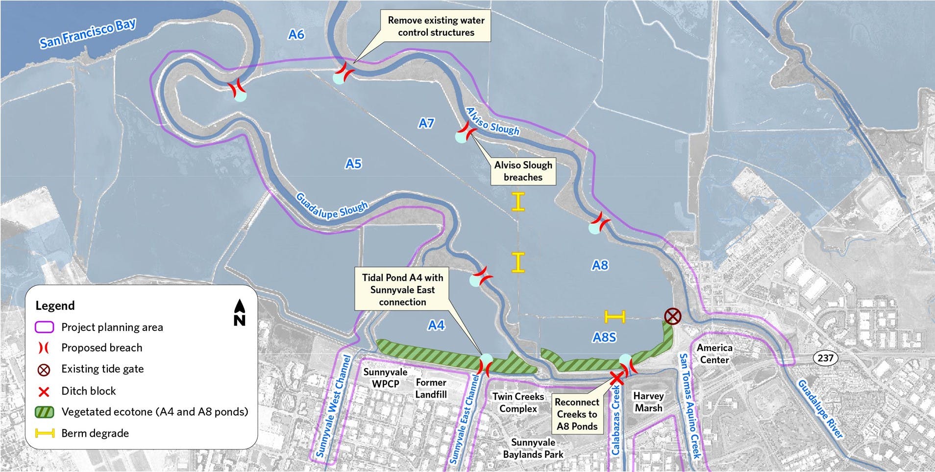
The Calabazas/San Tomas Aquino (STA) Creek-Marsh Connection Project is a groundbreaking effort—the first of its kind in the Lower South San Francisco Bay—to reconnect creeks with marshes using nature-based solutions. Spearheaded by Valley Water, the Project will restore approximately 1,800 acres of tidal marsh, enhance 50 acres of freshwater and brackish marsh habitat, and improve over 4 miles of riverine habitat. By restoring long-severed connections between local creeks, historic salt ponds, and the Bay, the Project will supply sediment needed to rebuild the pond bottoms to intertidal elevation—critical for the reestablishment of resilient tidal marsh ecosystems.

Modeling for Resilience and Restoration Design
To guide restoration design, the team applied a coupled three-dimensional hydrodynamic, wave, and sediment transport model to simulate water levels and sediment movement under current conditions and seven conceptual alternatives. These alternatives explore different configurations of levee breaches and creek realignments to understand their impact on sediment transport, erosion, and deposition throughout the restoration area. Modeling results were crucial in identifying optimal breach locations and sizes to accelerate natural sedimentation—an essential factor for rebuilding tidal marshes. This strategic approach balances the goals of habitat restoration with flood risk reduction, helping shape a sustainable future for this dynamic landscape.
Planning for Sea Level Rise: Long-Term Resilience Modeling
To ensure the Project’s long-term success in the face of climate change, FlowWest is applying the Wetland Accretion Rate Model for Ecosystem Resilience (WARMER). This model was used to predict how tidal marsh and transitional habitats may evolve over the next 50 years under various sea level rise scenarios. By combining WARMER model outputs with sediment transport projections, the team can assess future wetland elevations and the persistence of restored habitats through mid-century and beyond. These forecasts will also inform simulations using the three-dimensional model to evaluate water levels and sedimentation in the Year 50 scenario—providing a detailed picture of the Project’s capacity to support resilient, self-sustaining tidal marsh habitat over time.
